

Flash floods, river flooding and coastal inundation: how ClimateTech is reshaping flood resilience
Long before water reaches a home, a flood is already taking shape elsewhere: in a warmer atmosphere, across a saturated catchment, within a drainage network nearing capacity, or along a coastline where the baseline sea level is steadily rising.
Satellites, connected sensors, hydrodynamic models, artificial intelligence, high-resolution mapping, smart retention systems and automated defences now operate at different points along this chain. Their role is no longer simply to forecast flooding. It is to translate hazard into impact, and impact into action.
River flooding, surface water flooding and coastal inundation can also converge, particularly when intense rainfall, overwhelmed drainage systems, high tides and storm surges coincide.
ClimateTech will not prevent floods from occurring. What it can do is replace late reaction with anticipatory action: forecast where the water will go, make room for it, protect people and assets, and accelerate recovery.
Flooding is becoming a systemic risk
Floods affected every continent in 2025. The extreme events supplement to the State of the Global Climate 2025, published by the World Meteorological Organization (WMO), documents major events in Pakistan, Sri Lanka, Africa and the United States.
In Pakistan, monsoon flooding killed 1,037 people and damaged or destroyed more than 229,000 homes. In Sri Lanka, Cyclone Ditwah and persistent rainfall caused more than 640 deaths. In Texas, the flash floods of July 2025 killed 135 people.
These events did not share the same physical cause. Their common denominator lay elsewhere: water intersecting with highly exposed populations, buildings and infrastructure.
Land sealing, development on floodplains, the condition of drainage networks, topography and emergency response capacity all influence whether a natural hazard becomes a disaster, as the WMO highlights in its overview of Floods.
The first months of 2026 reinforced the complexity of that relationship. Analyses by World Weather Attribution of extreme rainfall show how climate change, urbanisation, saturated soils and vulnerability can combine to magnify flood impacts.
A forecast has little value unless it changes a decision: anticipating impacts, identifying which infrastructure must be protected first, mobilising resources and triggering emergency measures.
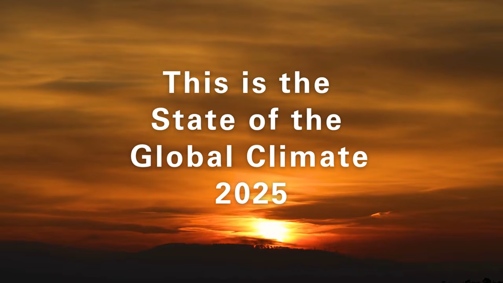
State of the Global Climate report 2025 – English
State of the Global Climate 2025, published by the WMO, 23 March 2026 © WMO
When different sources of flooding converge
In coastal cities and deltas, high river flows, intense rainfall, tides and storm surges can converge. Saturated drainage networks may no longer be able to discharge rainfall effectively, while pumps and flood protection systems approach their operational limits.
The Intergovernmental Panel on Climate Change (IPCC)
considers that rising sea levels, heavier precipitation and high river flows will increase the risk of compound flooding in coastal cities.
An intervention upstream can alter both water volumes and flow velocities downstream. Flood risk therefore needs to be understood across the entire system, from catchment to city to coastline.
The sea no longer floods only during storms
According to the WMO, the average rate of global sea-level rise increased from 2.1 mm per year between 1993 and 2002 to 4.1 mm per year between 2016 and 2025.
This rise shifts the baseline upon which tides, waves and storm surges act. Coastal flooding can therefore occur without a cyclone or an exceptional weather event.
In 2020, around 896 million people lived in low-lying coastal zones less than 10 metres above sea level. The IPCC estimates that this population could exceed one billion by 2050. Extreme sea levels historically experienced once a century could become annual events across many coastal regions by 2100.
In some deltas and major cities, land subsidence further compounds the exposure.
Coastal risk is therefore not changing solely because storms may become more damaging. The baseline from which their impacts are felt is rising too.
More water in the atmosphere, less room in the city
The amount of water vapour the atmosphere can hold increases by approximately 7% for every degree of warming, according to the Clausius-Clapeyron relationship. Extreme rainfall intensity therefore tends to increase, although the effect varies significantly by region.
Within cities, roads, car parks and buildings accelerate runoff and concentrate water in streets, tunnels, basements and drainage systems.
Urban areas consequently face a dual constraint: potentially heavier rainfall and less space in which to slow, absorb or temporarily store it.
The crisis does not end when the water recedes
According to the World Health Organization (WHO),
drowning accounts for around three quarters of flood-related deaths. Water contamination, mould, disruption to healthcare, damage to essential networks and pollution can extend the health and economic consequences long after floodwaters have receded.
Wetlands, floodplains and mangroves, by contrast, can slow flows and temporarily store part of the flood volume.
Adaptation therefore begins well before water reaches the city, by restoring the landscape’s capacity to hold and slow it.
Forecast: turning data into decisions
Satellites, sensors, weather models, hydrology, hydraulics and artificial intelligence are bringing flood forecasting progressively closer to operational decision-making.
FloodMapp: translating water depth into impact
Founded in Australia, FloodMapp
develops operational forecasting and mapping tools for emergency services and infrastructure operators.
Its models combine rainfall forecasts, river levels, catchment characteristics and topographic data to estimate flood extent and depth. The company states that its system can provide localised information between 6 and 72 hours in advance.
The value lies not simply in knowing that water is coming, but in knowing what to do next: close a bridge, define an evacuation zone or position emergency teams before flooding begins.
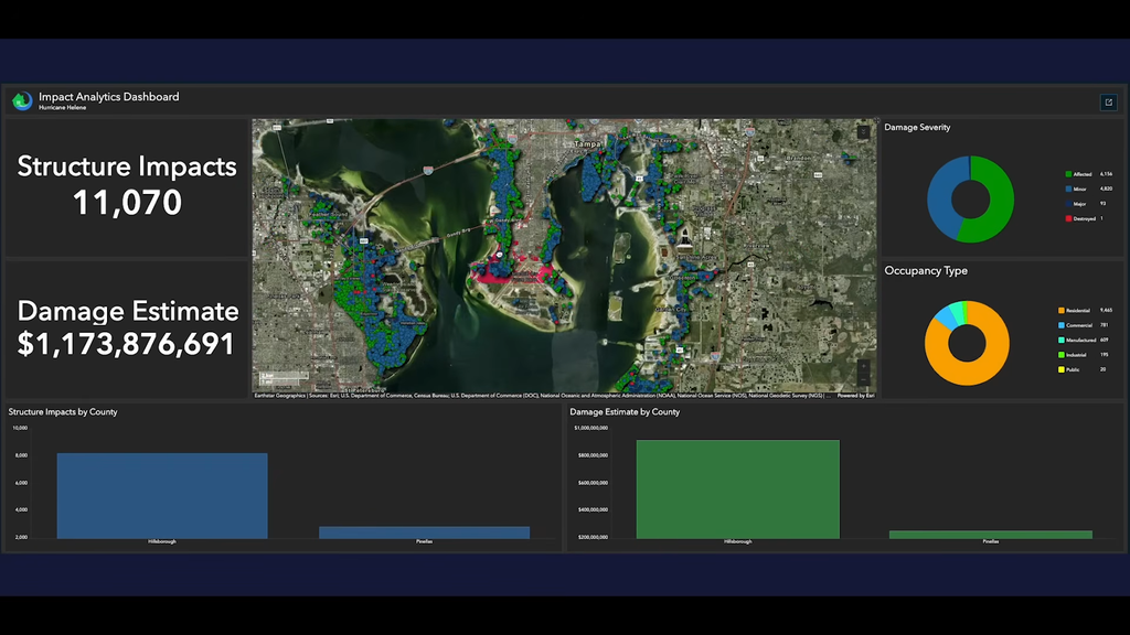
Evolution of flood extent in Asheville during Hurricane Helene, 27 September 2024 © FloodMapp
Previsico: forecasting surface water flooding
Previsico focuses on surface water flooding.
Its hydrodynamic models simulate how water moves through streets, low-lying areas and the built environment. The company provides warnings of up to 48 hours, at a resolution designed to identify individual properties, roads and infrastructure likely to be affected.
Forecasting becomes immediately actionable: vehicles can be moved, stock protected, electrical systems shut down or an underpass closed before the water arrives.
Forecasting becomes immediately actionable: vehicles can be moved, stock protected, electrical systems shut down or an underpass closed before the water arrives.
Fathom produces global flood mapping across river, surface water and coastal hazards.
Its models combine terrain, hydrology and hydraulics to estimate potential flood depths across different probabilities of occurrence. Its Climate Dynamics framework also allows users to assess how risk may evolve through to 2100.
These datasets are used in insurance, engineering, property, finance and spatial planning. The objective is no longer simply to identify where flooding may occur, but to compare assets, scenarios and adaptation investments on a consistent basis.
Floodbase: from flood mapping to financial response
Floodbase combines satellite observations, artificial intelligence, gauges and hydrological models to monitor flood extent, including in areas where ground-based measurements remain sparse.
Satellite data still needs to be interpreted alongside local observations to distinguish floodwater from permanent rivers, lakes, saturated soils or wet vegetation.
It can also become a financial trigger. In Italy, the platform has been used in parametric insurance schemes designed to accelerate payouts following flood events.
Climate data therefore moves beyond measuring exposure. It can become part of the mechanism through which recovery capital is released.
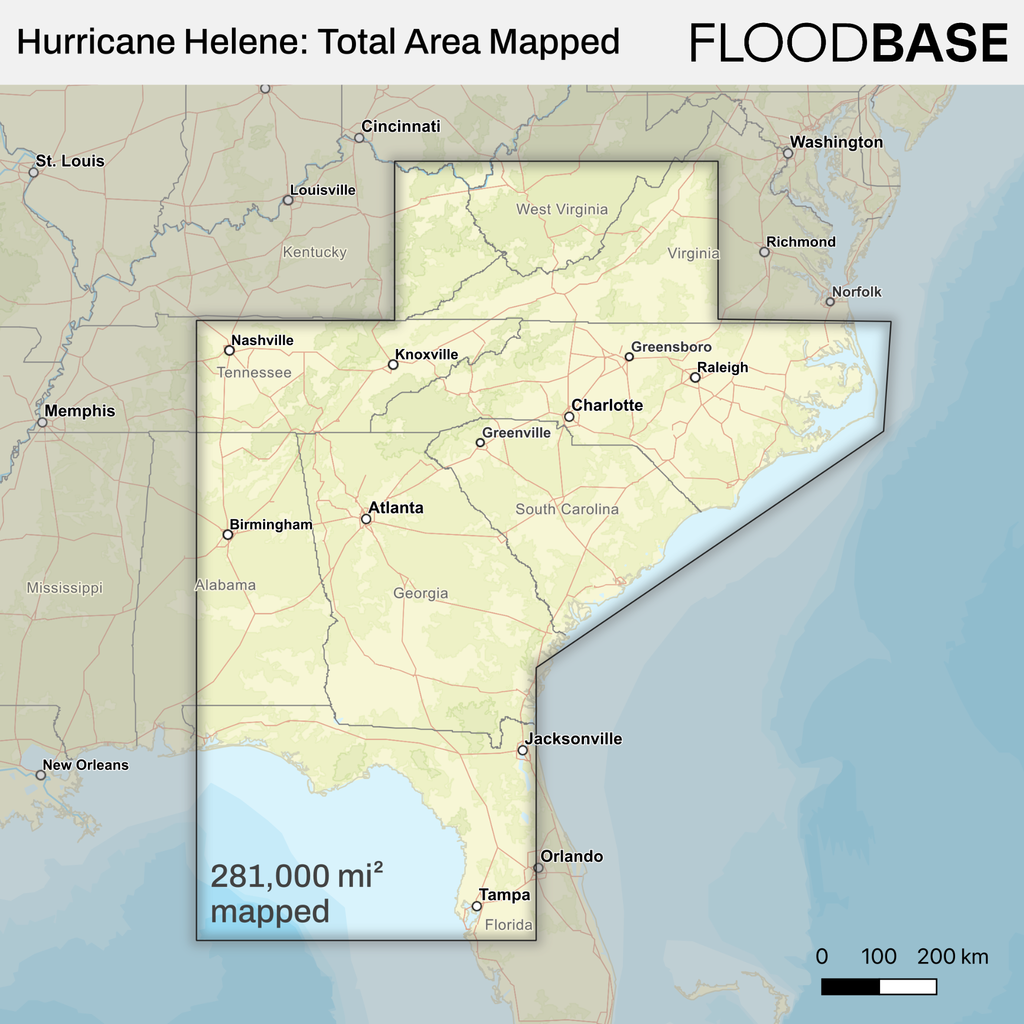
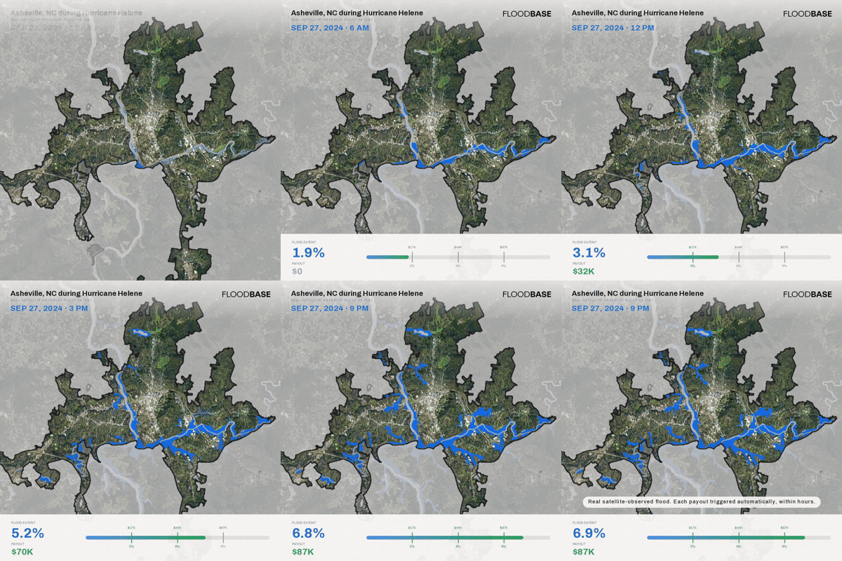
Evolution of flood extent in Asheville during Hurricane Helene, 27 September 2024. Visualisation from continuous flood monitoring conducted for FEMA © Floodbase
Control: treating the city as hydraulic infrastructurePiloter : transformer la ville en infrastructure hydraulique
A city is itself a hydraulic system.
Drainage networks, retention basins, pumps, roads and flood defences form an interconnected infrastructure whose operation can increasingly be managed through real-time data.
The objective is no longer simply to remove water as quickly as possible. It is to determine where to slow it, where to store it and when to release capacity.
Opti: creating capacity before the storm
Through real-time control, Opti turns retention basins into adaptive infrastructure.
Smart control does not increase the physical hydraulic capacity of a territory. It enables existing storage to be used more intelligently while reducing peak flows downstream.
Weather forecasts, water-level sensors and automated valves adjust stored volumes and discharge rates. Ahead of intense rainfall, a basin can be partially emptied to create additional capacity. During the event, outflow can then be regulated to reduce pressure on downstream systems.
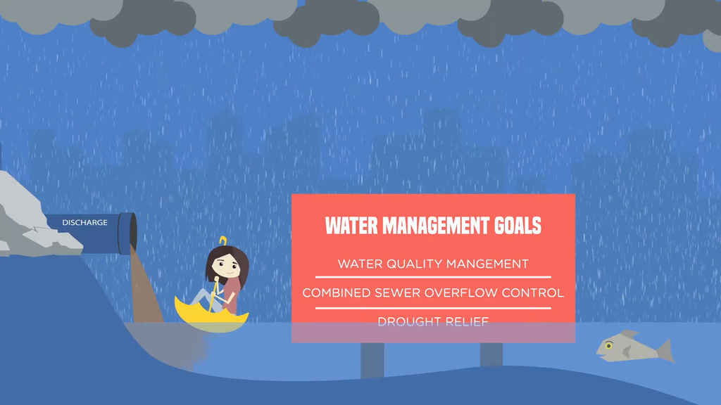
Adaptive stormwater infrastructure management using weather forecasts © OptiRTC, Inc.
Giving water space
Wetland, floodplain and mangrove restoration, urban depaving and designated flood expansion areas all follow the same principle: increasing a landscape’s ability to slow, absorb and store water.
Flood resilience is therefore becoming a hybrid architecture, combining engineered infrastructure, data, automation and ecosystems.
Protect: from individual buildings to entire coastlines
Adaptation also extends to physical defences, buildings and coastal infrastructure.
ECOncrete: turning coastal structures into ecological infrastructure
ECOncrete develops concrete formulations, textures and structural designs intended to improve the ecological performance of marine infrastructure.
Its technology can be integrated into seawalls, quays, revetments, harbour structures and breakwaters to encourage marine organisms to colonise artificial surfaces.
In New York, the Living Breakwaters project illustrates how coastal protection can combine reduced wave energy and erosion with habitat creation.
A protective structure can therefore become ecological infrastructure too.
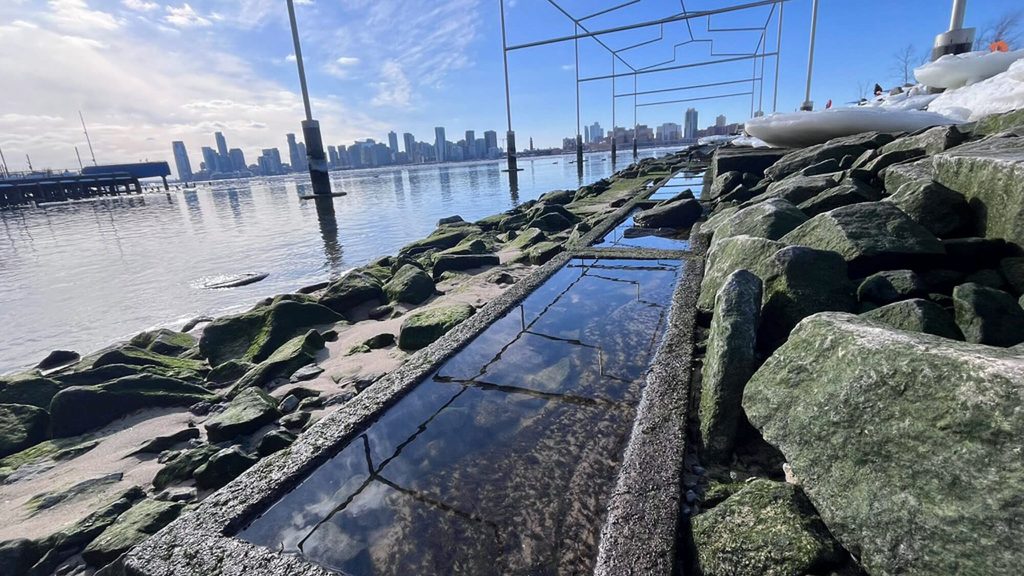
At Gansevoort Peninsula in New York, ECOncrete integrates intertidal habitat into coastal infrastructure, allowing a single intervention to support both shoreline resilience and ecological restoration © ECOncrete Technologies, Gansevoort Peninsula / Hudson River Park
FloodFrame: a barrier activated by the flood itself
FloodFrame uses a permanent flood barrier concealed below ground around a building.
As water levels rise, hydrostatic pressure deploys a waterproof membrane around the property, without electricity or human intervention at the moment of flooding.
The system nevertheless needs to form part of a wider resilience strategy, alongside non-return valves, raised electrical equipment, flood-resistant materials and an evacuation plan.
FloodFlash: shortening the distance between loss and recovery
FloodFlash combines a water-depth sensor with parametric insurance.
When water reaches a threshold specified in the policy, a payout can be triggered without waiting for a complete assessment of physical damage. The resulting liquidity can finance clean-up, equipment replacement or temporary measures to maintain business continuity.
As with any parametric insurance product, there remains a potential mismatch between the contractual trigger and the actual loss sustained.
Financial resilience thus becomes an extension of physical protection.
Simulate and decide: when climate risk becomes financial data
Simulation connects observation, forecasting and action.
A territorial model can combine topography, rivers, drainage networks, buildings, roads, weather forecasts, tides, waves and flood defences to test competing strategies: restoring a wetland, enlarging a retention basin, strengthening a seawall, closing a tunnel or relocating critical infrastructure.
Deltares: modelling compound flooding
The Dutch research institute Deltares works to improve the resilience of infrastructure to climate change, sea-level rise and land subsidence.
Its teams use models and scenario analysis to assess risk and test adaptation measures across hydraulic works, coastal infrastructure, roads, tunnels and quays. The approach also combines remote sensing, numerical modelling and Nature-based Solutions.
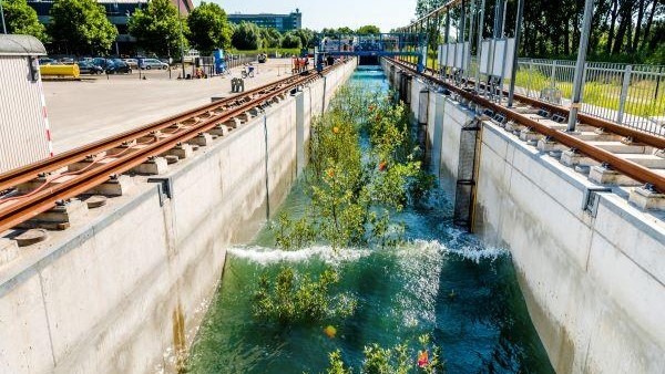
Willows in the Delta Flume at Deltares, an experimental facility used to study interactions between water, vegetation and infrastructure © Deltares
Along coastlines, Deltares integrates hydrodynamics, waves, sediment transport, morphology and ecology to assess the effects of seawalls, breakwaters, reclamation and other structures.
An intervention can alter currents, sediment transport or erosion well beyond its own footprint. Modelling these interactions from the design stage makes it possible to assess resilience not only at the scale of the structure, but across the wider coastal system.
When flood risk enters the balance sheet
Flood mapping is changing the way insurers, investors, banks, property owners and infrastructure operators evaluate physical exposure.
Satellite data, hydrodynamic models and climate scenarios are bringing together three variables that were long considered separately: exposure, probability of damage and economic cost.
A factory, warehouse, data centre or transport asset can now be assessed across multiple climate horizons and under different adaptation strategies.
ClimateTech is consequently moving into the field of risk intelligence: quantifying exposure to determine where to invest, what to protect and, in some cases, where further development no longer makes economic sense.
Technology cannot override geography
Models remain dependent on uncertain weather forecasts. Sensors can fail. Retention basins have finite capacity. A barrier may protect one property while diverting water towards another. Insurance can accelerate recovery, but it does not reduce the underlying hazard.
Technology can increase adaptive capacity. It cannot remove the physical constraints of a place.
Sea-level rise adds a further dimension: time. Protection that is adequate today may no longer be sufficient as the baseline continues to rise.
On the most exposed coastlines, adaptation will therefore require a combination of physical protection, mangrove and saltmarsh restoration, building adaptation, tighter controls on development and, in some locations, planned retreat.
The technological divide matters too. Many of the regions most exposed to flooding have fewer gauges and monitoring systems, less financial capacity and more limited emergency services. An alert has no value unless it reaches those at risk, is understood and leads to a viable course of action.
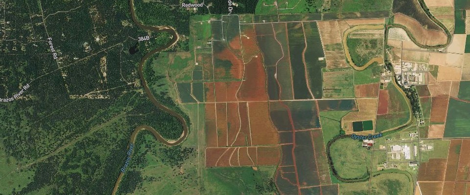
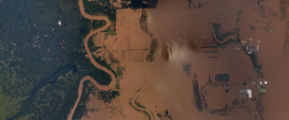
Flooding in Houston following Hurricane Harvey, August 2017. Aerial imagery documents the extent of inundation and its impact on infrastructure and urban areas © NOAA National Geodetic Survey
A new architecture of resilience
Climate change is acting simultaneously on the atmosphere, catchments and oceans. Effective responses must connect those same scales.
Rainfall has to be understood from cloud to catchment, and from catchment to city. River flooding from upstream flows to the infrastructure in its path. Sea-level rise from long-term climate projections to its consequences for coastlines, buildings and critical assets.
Technology can now observe water, simulate its movement, anticipate impacts, manage storage, protect assets and accelerate financial recovery.
Its effectiveness, however, depends on something broader than technology itself: its integration with planning, infrastructure, ecosystems and local capacity to respond.
ClimateTech cannot override geography. It can make geography measurable, foreseeable and, crucially, actionable.