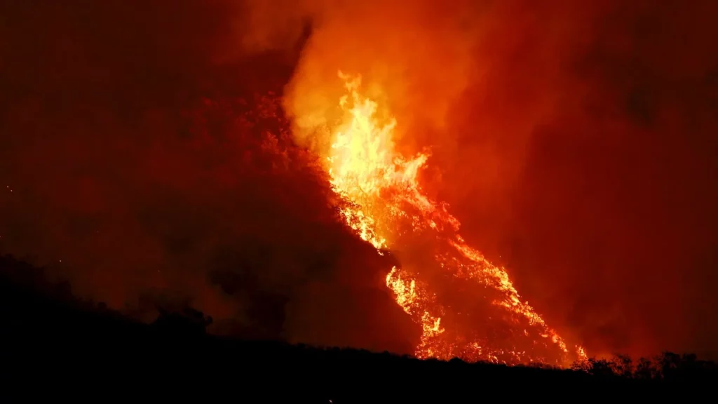
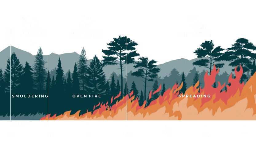
From orbit to a firefighter’s helmet, technology is transforming the fight against wildfires.
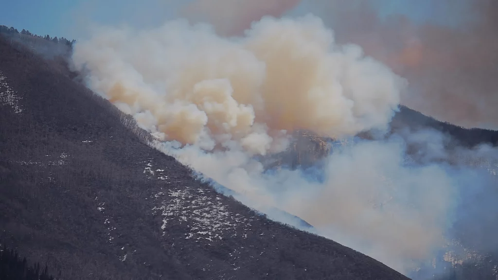
Forest fires are no longer tackled only once the flames are visible. Thermal satellites, artificial intelligence, gas sensors, drones, robots and other fire detection technologies are now deployed at every stage: anticipating risk, detecting the outbreak of a fire, predicting its spread, guiding emergency services and assessing the damage.
This technological evolution addresses a paradox. In 2025, the area burnt globally was one of the lowest in the past two decades. Yet several fires caused exceptional levels of human and economic destruction. The first few months of 2026 then saw a sharp increase in global fire activity.
The area burnt is therefore not sufficient to measure the severity of a season or the fire risk to which areas are exposed. A fire sweeping through a sparsely populated savannah does not have the same consequences as a fire passing through an interface between forest and town, a habitat for endangered species or a densely built-up area.
Current situation, climate and biodiversity
A deceptively moderate level of activity in 2025
According to the study ‘Wildfires in 2025’, published in Nature Reviews Earth & Environment, approximately 335 million hectares were burnt worldwide in 2025. This is the second-lowest annual area recorded since 2002, approximately 16 per cent below the average for the period 2002–2024.
The fires emitted nearly 11 billion tonnes of CO₂, the third-lowest total in the series studied.
However, this statistical lull masks several regional crises. Fires in Los Angeles, South Korea and Europe caused more than 90 deaths and led to over 300,000 evacuations.
In Canada, 2025 marked the third consecutive year of extreme emissions linked to forest fires. In Canada’s boreal forests, cumulative emissions between 2023 and 2025 exceeded those of the previous fifteen years combined. This concentration of emissions in carbon-rich ecosystems illustrates the limitations of an analysis based solely on the global area burnt.
In Los Angeles, the fires of January 2025 claimed 31 lives, destroyed nearly 12,000 homes and forced more than 150,000 people to evacuate. Total economic losses are estimated at around 140 billion dollars. In terms of the scale of insured losses, these fires rank among the five most costly natural disasters ever recorded.
In Europe, repeated droughts and extreme heat have fuelled particularly disruptive wildfires: 28 deaths, more than 120,000 evacuations and six countries simultaneously requesting assistance through the European Union’s Civil Protection Mechanism. The United Kingdom also experienced its first mega-fire, covering more than 10,000 hectares.
The year 2025 thus confirms that a small area burnt globally can coexist with major disasters. The actual cost depends on the intensity of the fires, their location and the exposure of populations, infrastructure and ecosystems.
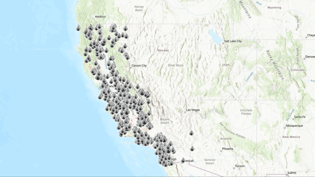
Map of wildfires recorded in California in 2025, showing their boundaries and key response data. © CAL FIRE
A record-breaking start to 2026
According to data compiled by World Weather Attribution and reported by Reuters, drawing in particular on the Global Wildfire Information System, more than 150 million hectares were burnt between January and April 2026.
This is the highest level recorded for this period in the data series studied, approximately 20 per cent above the previous record. As of 6 May, the global total exceeded 160 million hectares, compared with an average of around 110 million at this time of year.
Africa accounted for nearly 85 million hectares, 23 per cent more than its previous high. In Asia, the total reached around 44 million hectares, nearly 40 per cent above the previous regional record.
These figures include all areas affected by fire, notably savannahs and some agricultural land. They do not, therefore, correspond to 150 or 160 million hectares of destroyed forest.
In Europe, the official reference for monitoring fires is the European Forest Fire Information System, part of the Copernicus programme.
Climate change is creating more favourable conditions
Climate change does not directly cause every fire, but it does contribute to an increased risk of fire. Fires are often still caused by human activity, electrical infrastructure, lightning or accidents.
However, global warming is altering the environment in which these fires start: higher temperatures, drier vegetation, longer droughts and more extended fire seasons.
An attribution study focusing on the Los Angeles fires concluded that climate change had increased the probability of weather conditions conducive to such fires by around 35 per cent. The analysis also highlighted a lengthening of the dry season and a decrease in autumn rainfall in the region.
In South Korea, an analysis by World Weather Attribution estimated that global warming had roughly doubled the probability of the conditions associated with the deadly fires of March 2025. The intensity of the index combining heat, dry air and wind is thought to have increased by around 15 per cent.
These results must be interpreted carefully. An attribution study can measure the probability of favourable weather conditions, their intensity, the duration of the season or the area burnt. These indicators describe different aspects of fire risk.
On top of this underlying warming, there is also natural variability. On 2 June 2026, the World Meteorological Organisation estimated there was an 80 per cent probability that an El Niño event would develop between June and August 2026.
El Niño does not cause more fires everywhere, but it can increase the risk of fire in certain regions. It alters temperature and rainfall patterns, increasing the risk of drought in some regions and bringing more rain to others.
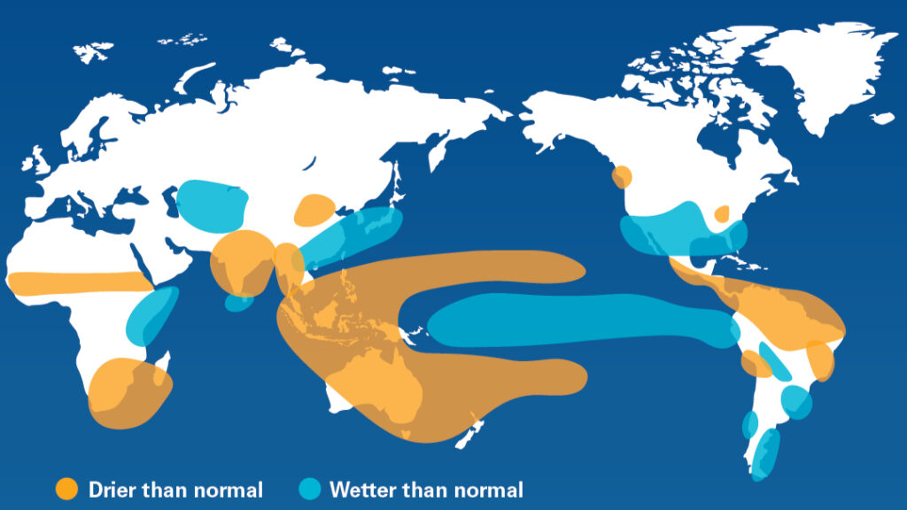
El Niño alters rainfall patterns in various regions of the world © World Meteorological Organization
Growing pressure on biodiversity
A study led by Xiaoye Yang and published in Nature Climate Change assessed the future exposure of 9,592 non-marine species already identified as vulnerable to an increase in the frequency or intensity of wildfires.
Under the intermediate climate scenario SSP2-4.5, the researchers project a 9.3 per cent increase in global area burnt and a rise in fire exposure for around 83.9 per cent of the species studied.
This result does not mean that 83.9 per cent of all species on the planet are directly threatened. It relates to a group of species already recognised as being sensitive to changes in fire regimes.
Certain ecosystems, such as several savannahs and Mediterranean forests, are adapted to periodic fires. The danger increases when fires become too frequent, too intense or occur at an unusual time of year, reducing the time available for vegetation and animal populations to recover.
Beyond immediate mortality, repeated fires can prevent the regeneration of habitats and cause certain ecosystems to shift permanently towards a new type of vegetation that is less favourable to the species that previously inhabited them.
The consequences can be long-lasting: destruction of shelters and food sources, habitat fragmentation, soil erosion, watercourse pollution, the spread of invasive species and changes to vegetation.
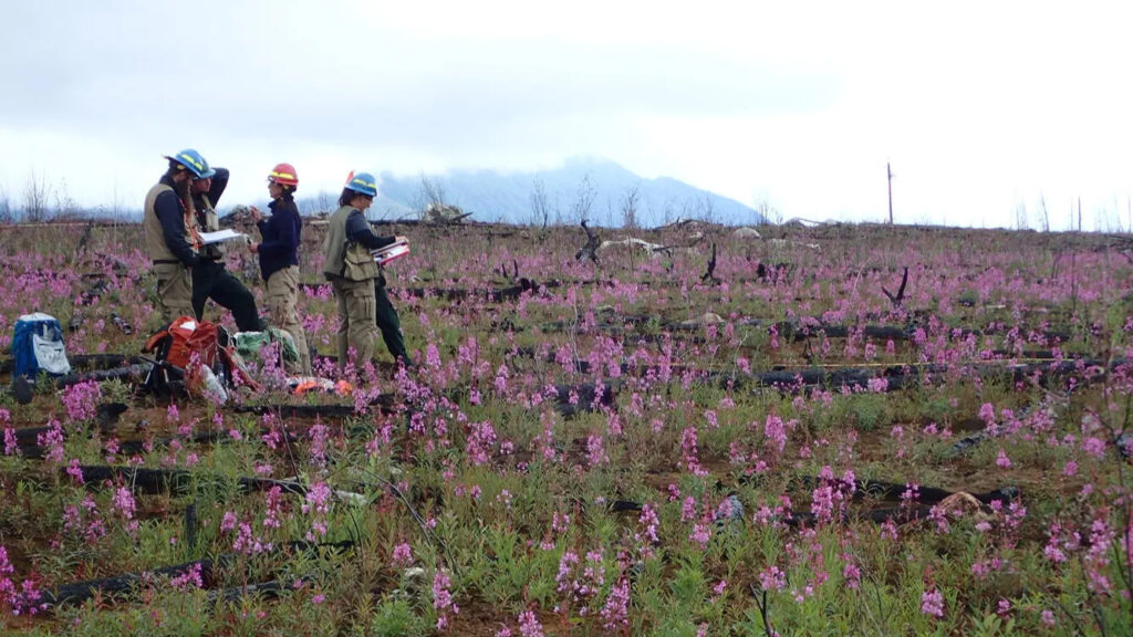
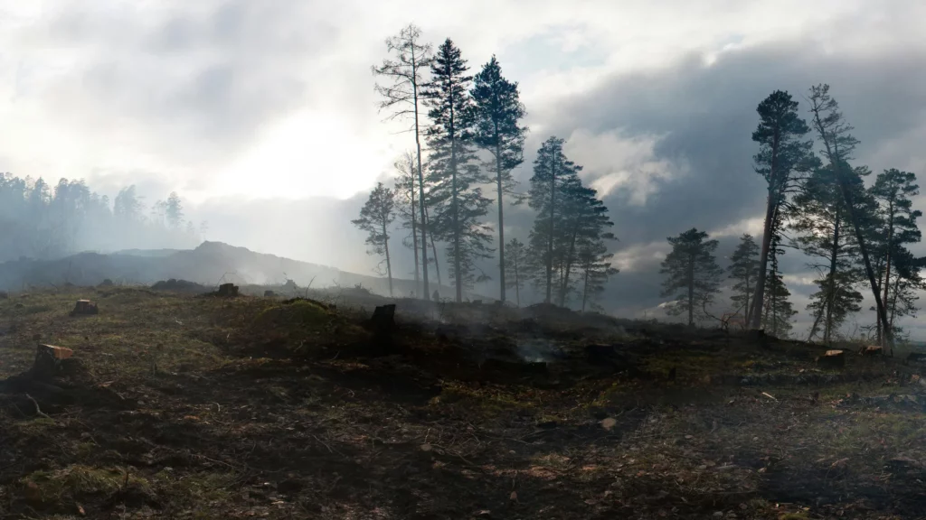
More frequent or more severe fires can bring about lasting changes to ecosystems by altering vegetation, habitats and the carbon cycle. © USGS Alaska Science Centre
Innovations: anticipating, detecting and responding
Thermal satellites, gas sensors, smart cameras, drones, robots and simulation tools are used at every stage of fire management.
Their effectiveness depends less on individual technologies than on their integration into a single operational chain – a comprehensive chain of fire detection, analysis and response.
Satellites: detecting before the fire spreads
FireSat, a constellation dedicated to wildfires
FireSat is a constellation project specialising in wildfire detection, monitoring and characterisation. It is led by the Earth Fire Alliance, Muon Space and Google Research.
Once fully deployed, the constellation is expected to observe the world’s most at-risk regions approximately every twenty minutes.
The programme’s partners state that its instruments will be able to detect fire hotspots measuring approximately 5 × 5 metres. This performance is based on information provided by the consortium and does not constitute a guaranteed threshold under all observation conditions.
An initial prototype was launched on 14 March 2025. The first images published by the Earth Fire Alliance included, in particular, a small roadside fire in Oregon that had not been detected by the other satellite systems cited by the programme.
The infrared instruments are also designed to measure the perimeter, spread and intensity of fires.
The launch of the first three operational satellites is still scheduled for mid-2026. The full constellation is set to gradually exceed 50 satellites by 2030. Google.org has contributed $13 million to the programme.
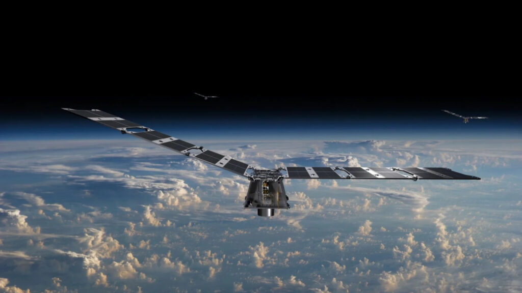
Condor modular satellite platform, designed to accommodate various payloads, particularly for Earth observation missions. © Muon Space
OroraTech: thermal analysis in orbit
The German company OroraTech is developing nanosatellites equipped with thermal infrared sensors and a platform dedicated to fire monitoring.
The service, also presented by the European Space Agency, combines satellite data, automated analyses and complementary Earth observation sources.
Part of the processing is carried out directly on board to select priority information before it is transmitted to the ground. This architecture can speed up alerts where orbital coverage and communications permit.
However, the response times of a few minutes mentioned by OroraTech are not guaranteed for every territory or for every satellite pass.
OroraTech’s satellite platform dedicated to the detection, monitoring and analysis of wildfires. © OroraTech
ICEYE: mapping damage despite the smoke
The Finnish company ICEYE uses radar satellites to map the damage caused by fires.
Synthetic aperture radar can observe the ground at night, through clouds and beneath thick plumes of smoke.
During the 2025 Los Angeles fires, the company reported 99 per cent accuracy for buildings classified as destroyed. Its detailed analysis specifies that this figure corresponds to the proportion of buildings correctly identified amongst those reported as destroyed by its system.
It is therefore not a general fire detection rate. The service is primarily deployed during and after a disaster to rapidly assess the extent of the damage.
Sensors and cameras: making the most of the first few minutes
Dryad Networks: detecting combustion gases
The German company Dryad Networks is developing Silvanet, a fire detection solution based on a network of solar-powered sensors designed to detect the first signs of a fire.
The Silvanet sensor’s documentation states that it measures, amongst other things, carbon monoxide, volatile organic compounds and particles produced during pyrolysis or combustion.
It can therefore detect certain smouldering fires before a clearly visible plume appears.
However, the speed of the alert depends on the distance from the source of the fire, the fuel, the wind, the terrain and the density of the network. Large-scale deployment also requires suitable connectivity and regular maintenance.
Silvanet sensor installed in a forest to provide early detection of gases and particles produced by combustion. © Dryad Networks
Pano AI: monitoring the horizon
Pano AI combines high-definition panoramic cameras with image analysis algorithms.
Installed at high vantage points, the cameras detect plumes of smoke. Artificial intelligence continuously analyses the images, after which operators can verify the alerts before they are forwarded to the emergency services.
The solution is used by local authorities, emergency services and electricity network operators in the United States, Canada and Australia.
Like all optical systems, its effectiveness depends on visibility, terrain, fog, cloud cover and the position of the cameras.
Pano AI’s panoramic camera, used to detect smoke plumes and improve real-time situational awareness. © Pano AI
Pyronear, an open-source alternative
In France, the Pyronear association is developing open-source detection tools based on cameras, artificial intelligence models and monitoring software.
Its open-source approach facilitates code auditing, experimentation and the reuse of tools.
However, the transition to operational use requires sufficient geographical coverage, a reliable power supply, effective management of false alarms and integration into fire service procedures.
Drones and robots: responding without putting crews at risk
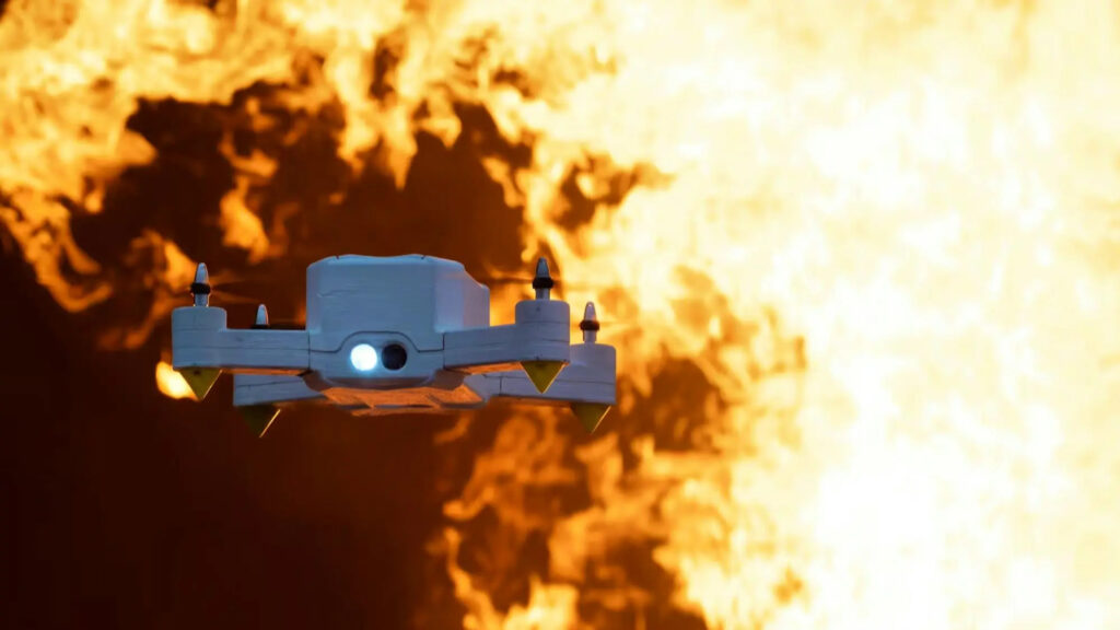
Seneca: autonomous initial response
The US company Seneca is developing autonomous drones designed for the detection and initial attack of fires.
According to specifications provided by the company, its drones can carry over 100 pounds of fire-extinguishing agent – equivalent to more than 45 kilograms – and discharge it at a pressure exceeding 100 PSI.
Seneca claims to have demonstrated its system on live fires in collaboration with fire services in four US states.
The aircraft are primarily designed to tackle fires that are still small in scale and in areas that are difficult to access. Their value lies not in the volume of water they carry – which is far less than that of a water-bombing aircraft – but in the speed and precision of their response.
On 20 October 2025, the company announced that it had raised $60 million to increase its production capacity and prepare for its first deployments.
These demonstrations do not yet prove the system’s effectiveness on a large scale under all conditions of wind, terrain and fire intensity.
Seneca’s autonomous drone designed to detect and carry out an initial response to fire outbreaks. © Seneca
FireDrone: approaching areas that are too hot
FireDrone is a heat-resistant aircraft, developed on the basis of research carried out by Empa and Imperial College London.
Imperial College London describes it as a reconnaissance drone designed for use in building fires and wildfires.
A presentation by the Swiss Federal Administration states that its aerogel-based insulation enables it to operate in environments reaching temperatures of around 200 °C.
The drone can carry cameras and sensors to gather information in areas that are too dangerous for conventional aircraft or human responders. Its primary mission is reconnaissance, not water delivery.
FireDrone, a reconnaissance drone designed to operate near areas subject to extreme temperatures. © FireDrone
Colossus, the fire service’s heavy-duty robot
The Colossus tracked robot from Shark Robotics assists firefighters in environments subject to heat, smoke or the risk of collapse.
It can carry out reconnaissance, transport equipment, move loads and be fitted with a water cannon.
The Paris Fire Brigade deployed it during the Notre-Dame fire in April 2019.
Depending on its configuration, the robot weighs around half a tonne. It is remotely operated: crews retain control over its movements and the response strategy.
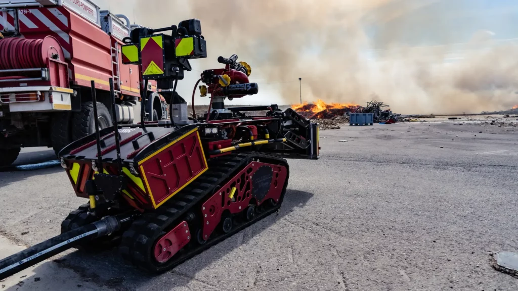
Colossus robot equipped for reconnaissance, equipment transport and water spraying in hazardous environments. © Shark Robotics
The augmented firefighter: seeing, communicating and saving water
Longan Vision: hands-free thermal imaging
The Canadian company Longan Vision develops thermal imaging systems for firefighters.
Its Fusion Vision System combines a helmet-mounted thermal camera with a display positioned in the field of view.
The device makes it easier to navigate through smoke, search for victims, identify obstacles and locate heat sources, whilst keeping the user’s hands free.
It is more accurate to refer to this as thermal imaging with a head-up display rather than full augmented reality. Its effectiveness depends in particular on battery life, ergonomics and compatibility with protective equipment.
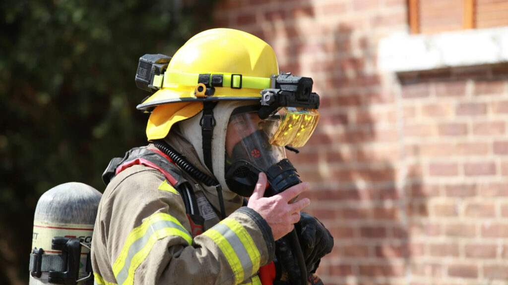
The Fusion Vision System combines a thermal camera attached to the helmet with a display positioned within the firefighter’s field of vision. © Longan Vision
HEN Technologies: more precise water control
HEN Technologies develops nozzles, monitors and pump control systems integrated into its Fluid-IQ platform.
This equipment allows for more precise adjustment of flow rates, pressures and the shape of the jet.
The manufacturer claims that, for certain configurations, fires can be extinguished up to three times faster whilst reducing water consumption by 67 per cent.
These performance claims are made by HEN Technologies. They cannot be generalised to all types of fires without further independent assessments.
goTenna: maintaining off-network communications
The US company goTenna develops compact radios capable of creating a mesh network between emergency responders, without relying on mobile coverage, Wi-Fi or fixed infrastructure.
When paired with a phone or tablet, this equipment enables the sharing of GPS positions, encrypted messages, map-based perimeters and operational alerts. It complements traditional voice radios in remote areas or when networks are overloaded.
goTenna is also taking part in a project supported by NASA, alongside Urban Sky and the Jet Propulsion Laboratory.
The system combines stratospheric microballoons, infrared sensors and mesh relays to transmit maps of hotspots and fire perimeters to ground teams in near real time.
As part of NASA’s FireSense programme, it illustrates the evolution of operational communications, which now carry voice, positions, thermal data and alerts.

A stratospheric microballoon used as an observation platform and communications relay when ground-based infrastructure is unavailable. © Urban Sky
Forecasting, simulation and decision support
Simulation tools applied to wildfires combine topography, vegetation, fuel moisture, weather data, satellite observations, drone data, the location of emergency services, road networks and exposed buildings.
This dynamic representation makes it possible to explore different scenarios: the likely direction of the fire front, the exposure of homes, evacuation routes or the positioning of firefighting resources.
Simulations can be updated as new data becomes available. Their accuracy depends, however, on the quality of observations, the speed of computation and the models’ ability to incorporate rapid changes in wind and fire behaviour.
These systems do not predict the future with certainty. They produce probabilistic scenarios designed to inform decision-making.
Climate Innov: turning fire behaviour into operational scenarios
The French company Climate Innov develops environmental risk analysis and decision-support software, with an application dedicated to civil protection and wildfire management.
Its SecuFire Action solution combines geospatial analysis, satellite data, weather information, predictive modelling and artificial intelligence to simulate the potential spread of a fire.
The aim is not to detect a fire outbreak directly, but to help emergency services understand how a fire could evolve according to topography, land cover, wind direction, wind intensity and vegetation moisture.
Climate Innov presents SecuFire Action as an operational planning and decision-support tool for incident commanders during wildfire response. The company also indicates that the solution may support prevention, land-use planning and wildfire risk analysis.
Its value therefore lies at a different level from satellites, sensors or drones. It transforms heterogeneous observations into usable scenarios: potentially exposed areas, possible movement of the fire front, location of sensitive sites and support for positioning firefighting resources.
Climate Innov states that its technology can reduce decision-making time by two to three hours and help limit the area affected by fires. These figures should be presented as company performance claims, rather than independently established results.
According to Sophianet, Climate Innov launched a minimum viable product in 2025, carried out field tests during summer wildfires and is aiming to commercialise its wildfire decision-support tool in 2026.
Climate Innov illustrates an important shift in wildfire management: the challenge no longer lies only in detection, but in the ability to convert multiple sources of data rapidly into clear, contextualised and operational decisions.
Climate Innov’s interface for analysing fire risk and simulating the spread of forest fires, designed to help civil protection services anticipate how a fire will develop and plan their response. © Climate Innov
NASA also offers several open-access tools:
- Fire Event Explorer allows users to visualise the progress and extent of a fire;
- FIRMS provides satellite data on active fires and thermal anomalies;
- NASA Worldview provides access to over 1,200 layers of imagery and satellite data.
Technologies to be integrated into a comprehensive strategy
Each technology family has its own limitations.
The frequency of satellite observations depends on their orbits. Cameras remain susceptible to terrain, smoke, fog and visibility conditions. Ground-based sensors require a sufficiently dense network, a reliable power supply and regular maintenance. Drones depend on their flight time, payload, wind conditions and air traffic regulations.
Digital models rely on the quality of meteorological and environmental data. Their accuracy decreases when fire behaviour changes rapidly or when available observations are incomplete. Connectivity also becomes critical when infrastructure is damaged, overloaded or absent.
Cost, maintenance and the ability to deploy on a large scale are key factors in the transition from a prototype to an operational service. The performance claims made by manufacturers must be subjected to independent assessments, common standards and trials conducted with fire services.
These technologies are no substitute for clearing undergrowth, reducing fuel loads, land-use planning or the maintenance of electricity networks. Nor do they eliminate the need for controlled burns where appropriate, ecosystem restoration, training for local residents or evacuation preparations.
Their main contribution lies in reducing response times, improving situational awareness, aiding decision-making and reducing human exposure.
This transformation also relies on public research and the provision of open data, maps and tools. In the United States, the USGS Wildland Fire Science programme studies the causes, consequences and ecological functions of fires in order to support fire and land managers before, during and after incidents.
Its work focuses in particular on landscape change, the effects of wildfires on water resources, the risk of debris flows following wildfires, and ongoing hazard assessment. These scientific facilities complement the solutions developed by companies by providing the knowledge required for their validation, operational integration and the long-term management of ecosystems.
This integrated approach lies at the heart of the resolution ‘Strengthening the global management of wildfires’, adopted at the seventh United Nations Environment Assembly, held in Nairobi from 8 to 12 December 2025.
Registered under the reference UNEP/EA.7/Res.7, it features on the official list of UNEA-7 resolutions and decisions.
From space to a firefighter’s helmet, deep tech is gradually transforming the fight against fires and wildfires.
The breakthrough is unlikely to come from a single machine, but rather from the ability to link these tools within a single operational chain: anticipating wildfires, detecting them, making decisions, responding and learning from each incident.